Exactly 500 years ago, in August of 1519, an expedition led by the Spanish explorer Hernando Cortés began marching inland into Mexican territory.
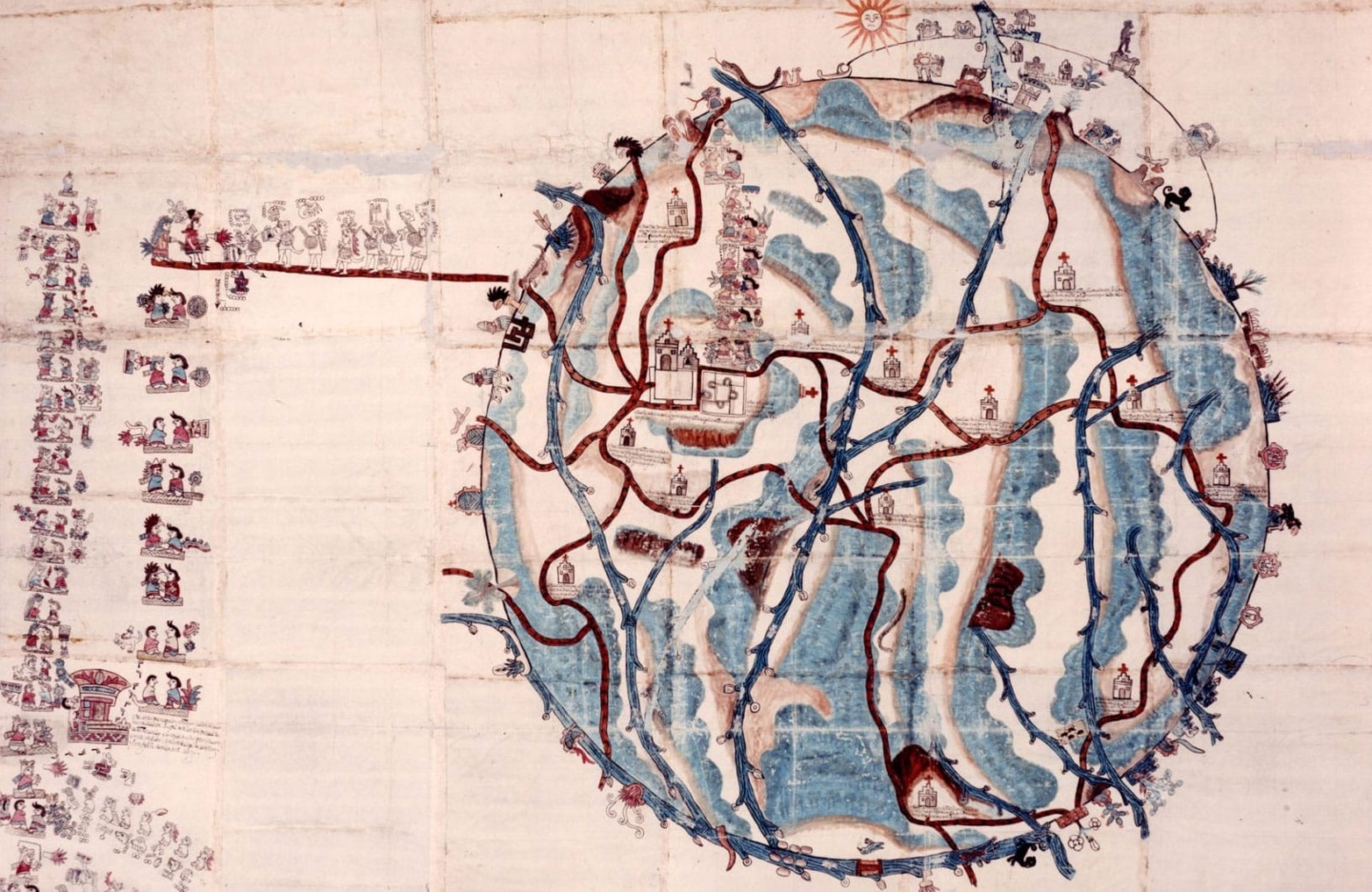
Just two years later, what today is Mexico City fell to an ethnically diverse army composed of both Spanish and local peoples from other cities, starting a long period of European colonization. This exhibition aims to expand our perspective on these events by featuring a selection of maps, known as Mapas de las Relaciones Geográficas, created by Indigenous artists around 1580. These unique documents show some of the visual strategies used by native communities for the endurance and perseverance of their cultures throughout the so-called colonial period and well beyond.
Additional Resources
Using the list of resources below, you can continue to explore and learn about the Mapas de las Relaciones Geográficas (RG) via a variety of websites, articles, and books. Please note that most book links direct you to the book’s publisher. You can locate the titles in your local library if you prefer not to purchase them through this or other vendors.
- Barbara E. Mundy. The Mapping of New Spain: Indigenous Cartography and the Maps of the Relaciones Geograficas. Chicago: University of Chicago Press, 1996.
- Alex Hidalgo. A Trail of Footprints. A History of Indigenous Maps From Viceregal Mexico. Austin: The University of Texas Press, 2019.
- Logan Wagner, Hal Box, and Susan Morehead. Ancient Origins of the Mexican Plaza: From Primordial Sea to Public Space. Austin: The University of Texas Press, 2013
- Alessandra Russo. El realismo circular: tierras, espacios y paisajes de la cartografía indígena novohispana siglos XVI y XVII. México City: Universidad Nacional Autónoma de México, Instituto de Investigaciones Estéticas, 2005.
- Mercedes MontesdeOca Vega, et. al. Cartografíadetradiciónhispanoindígena: mapasdemercedesdetierra, siglos XVI y XVII. México City: Universidad Nacional Autónoma de México: Archivo General de la Nación, 2003.
- Mapping Latin America: a cartographic reader. Edited by Jordana Dym and Karl Offen. Chicago and London: The University of Chicago Press, 2011.
- Mary Elizabeth Haude. “Identification of Colorants on Maps From the Early Colonial Period of New Spain (Mexico),” Journal of the American Institute for Conservation, Vol. 37, Num. 3, 1998, pp. 240-270.
- Matthew Restall. When Montezuma Met Cortés: The True Story of the Meeting that Changed History. New York: Ecco/Harper Collins, 2018.
- Matthew Restall. Seven Myths of the Spanish Conquest. New York: Oxford University Press, 2004.
- Repensar la conquista. Reflexión epistemológica de un momento fundador. Guy Rozat, editor. Biblioteca Digital de Humanidades de la Universidad Veracruzana, 2013.
- Miguel León-Portilla. The broken spears: the Aztec account of the conquest of Mexico. Boston: Boston Beacon Cop., 1962.
- Alfred W. Crosby Jr.. The Columbian exchange: biological and cultural consequences of 1492. Westport: Praeger, 2003.
- Blog Noticonquista del Proyecto de historia pública del Instituto de Investigaciones Históricas de la UNAM. You can also follow this on Twitter @noticonquista
- Denis Wood with John Fels. The power of maps. New York: Guilford Press, 1992.
- Matthew H. Edney. Cartography. The Ideal and Its History. Chicago: University of Chicago Press, 2019.
New Exhibitions Museum. Mariana Castillo Deball: Finding Oneself Outside. New Museum Of Contemporary Art
A Library for the Americas. The Nettie Lee Benson Latin American Collection. Julianne Gilland and José Montelongo, editors. Austin, The University of Texas Press, 2018.
Press
Credit
This exhibition is organized by Rosario I. Granados, Marilynn Thoma Associate Curator, Art of the Spanish Americas, Blanton Museum of Art in collaboration with LLILAS Benson Latin American Studies and Collections, the Harry Ransom Center, and the Dolph Briscoe Center for American History.